Wyoming is filled to the brim with free dispersed campsites – if you know where to find them.
The vast majority are located in the state’s eight national forests and across its over 18 million acres of public BLM land.
Today, I break down my 9 personal favorites (each with nearby alternatives) to help you plan your trip.
Quick Overview
Here are the free dispersed campsites I cover below:
- Firehole Canyon
- Shadow Mountain
- Granite Creek Road
- Vedauwoo Glen Road
- Upper Sunshine Reservoir
- Crazy Woman Canyon Road
- Sand Creek Public Access
- Ayres Natural Bridge Park
- Sand Mesa WHMA
Click on one that interests you to jump down for more info or browse them all on our Wyoming dispersed camping map.
Please always follow the Leave No Trace principles when dispersed camping, especially packing out all of your trash, including human waste.
My Favorite Dispersed Campsites in Wyoming
Here’s what I like (and dislike) about each of my favorite free dispersed campsites in Wyoming along with GPS coordinates and nearby alternatives for each.
Firehole Canyon

Firehole Canyon is my favorite place to camp near Flaming Gorge Reservoir.
Dispersed camping options are numerous here, but my favorite campsites are those right where the Green River meets the Flaming Gorge (just south of Firehole Canyon Campground) along FR 106, FR 060, FR 118, FR 33, and other nearby forest service roads.
Most of the access roads are well-maintained (many are even paved) and there are plenty of large, flat spots for boondocking in RVs and trailers of all sizes. Just keep your eyes open for deep sand before committing to a campsite.
The most sought after campsites are set right on the riverbank. Although the views are fabulous, these campsites are very exposed with almost no shelter from the wind or shade from the sun.
Important Tip: Don’t confuse this Firehole Canyon with Firehole Canyon in Yellowstone National Park (also located in Wyoming).
Other Free Campsites Nearby: Dispersed campsites are located up and down the length of Flaming Gorge Reservoir. On the Utah side, I’m a big fan of Jug Hollow.
See on YouTube: “Firehole Canyon in Flaming Gorge National Recreation Area” by stillmanroad
More Info:
Firehole Canyon is part of Ashley National Forest.
Dispersed camping is allowed for up to 16 days at a time.
Call the Flaming Gorge Ranger District for more info: (435) 784-3445
Official Map: Flaming Gorge Ranger District MVUM
Shadow Mountain
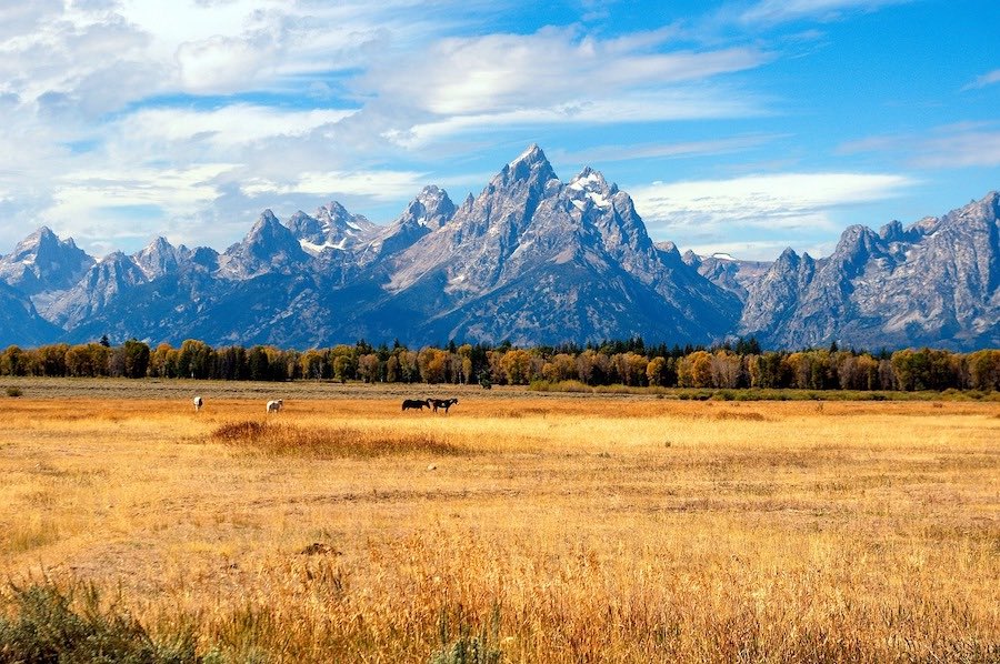
Dispersed camping certainly isn’t in short supply near Grand Teton National Park.
But, out of all the available options, Shadow Mountain stands out above the rest as my absolute favorite (see all my favorite Grand Teton free campsites).
The views of the Teton Range across Antelope Flats are incredible – quite possibly, the best from any free campsite in the United States. But these spectacular views means that these campsites fill up very quickly, especially in the summer months (by late morning, often even earlier).
RVs and trailers up to about 30 feet are usually fine at the lower campsites (take Antelope Flats Road past Mormon Row to Shadow Mountain Road for the smoothest approach). But, the upper campsites (actually on the mountain) are best left for high-clearance vehicles as the road gets extremely rough.
Important Tip: Like most dispersed camping near Grand Teton, you must now camp in designated dispersed campsites only at Shadow Mountain. I believe there are around 45 total.
Other Free Campsites Nearby: Spread Creek is another very popular designated dispersed camping area near Grand Teton National Park.
See on YouTube: “Incredible Views of the Tetons at this Campsite on Shadow Mountain” by Ben Stinnett
More Info:
Shadow Mountain is part of Bridger-Teton National Forest.
Designated dispersed camping is allowed for up to 5 nights at a time.
Call the Jackson Ranger District for more info: (307) 739-5400
Official Map: Jackson Ranger District MVUM
Granite Creek Road
Granite Creek Road offers up awesome dispersed camping just an hour southeast of Jackson Hole.
After turning onto Granite Creek Road (Forest Road 30500) from Highway 191 (about 11 miles east of Hoback Junction), you’ll see dispersed campsites almost immediately. Some are little more than road-side pullouts, but the majority are located well off the road. Many are large enough for several small to medium RVs or trailers to camp together.
The creek and surrounding Gros Ventre Range are absolutely stunning. Many of the campsites are large for several small to medium RVs or trailers to camp together. The catch is that Granite Creek Road is very washboarded and can take forever to navigate in a low-clearance vehicle or RV.
At the very end of Granite Creek Road is Granite Hot Springs Pool (a developed, concrete hot springs pool that costs $8 to use) and just before it is a natural hot springs right below Granite Falls. Both are very popular, so expect a ton of day-use traffic kicking up a lot of dust along the road.
Important Tip: After roughly 8 miles, you’ll come to a sign which clearly states dispersed camping isn’t allowed beyond that point. This sign is about a mile before Granite Creek Campground.
Other Free Campsites Nearby: Instead of turning onto Granite Creek Road, continue east on Highway 191 for 3 miles until you reach Forest Road 30530 to find more, slightly less busy, dispersed campsites.
See on YouTube: “Granite Creek WY” by Robert Berardinelli
More Info:
Granite Creek is part of Bridger-Teton National Forest.
Dispersed camping is allowed for up to 5 nights at a time.
Call the Jackson Ranger District for more info: (307) 739-5400
Official Map: Jackson Ranger District MVUM
Vedauwoo Glen Road
Vedauwoo is located about halfway between Laramie and Cheyenne just off I-80.
The area is best known for rock climbing and bouldering, but it’s also an excellent place for dispersed camping and boondocking, especially in the summer since the 8,500 feet in elevation helps you escape the scorching summer heat.
Many of the campsites here are large enough for RVs and trailers, including big rigs. The access road is well-graded with hard-packed gravel, but do expect minor washboarding. Scout out the “driveways” into potential campsites before committing as many are quite rough and/or sandy.
The free campsites here are all located just past Vedauwoo Campground in an area officially known as Vedauwoo Designated Dispersed Campsites. At some point just after the campground, the road changes names from Vedauwoo Glen Road to Forest Road 700.
Important Tip: You must now camp in designated dispersed campsites only along Vedauwoo Glen Road (Forest Road 700). I believe there are 97 total.
Other Free Campsites Nearby: Much of the surrounding Pole Mountain Area is also open to dispersed camping. I believe this is still true dispersed camping (not designated dispersed).
See on YouTube: “Vedauwoo, Medicine Bow National Forest, SE Wyoming” by Bearly Overlanding
More Info:
Vedauwoo Designated Dispersed Campsites are part of Medicine Bow-Routt National Forest.
Designated dispersed camping is allowed for up to 16 days at a time.
Call the Laramie Ranger District for more info: (307) 745-2300
Official Map: Pole Mountain – Laramie Ranger District MVUM (free on Avenza Maps)
Upper Sunshine Reservoir

Upper Sunshine Reservoir is one of my favorite places to camp in Northwest Wyoming.
It’s located roughly an hour south of Cody about 15 miles west of Meeteetse. It’s close to Yellowstone National Park as the crow flies, but takes about two hours to reach the East Entrance since a roundabout driving route is required.
Although dispersed campsites can be found on both sides of the reservoir, the most popular are along the northwest shore, especially near the boat ramp along Upper Sunshine Reservoir Road. Many are right on the lake itself.
Most of these campsites are wide open and spacious. This is a great spot for boondocking in RVs and trailers – aside from the lack of level ground. The access road is fairly smooth with nothing worse than moderate washboarding.
Other Free Campsites Nearby: Lower Sunshine Reservoir, about 6 miles closer to Meeteetse, is another great spot for dispersed camping nearby.
See on YouTube: “Upper Sunshine Reservoir – West of Meeteetse, Wyoming” by James Yule
More Info:
Upper Sunshine Reservoir is managed by the Wyoming Game and Fish Department.
Dispersed camping is allowed for up to 14 days at a time.
Call the Cody Regional Office for more info: (307) 527-7125
Official Map: WGFD Upper Sunshine Reservoir Online Map
Crazy Woman Canyon Road

Image Attribution: “Landscape” by Larry Lamsa, CC BY 2.0
Crazy Woman Canyon is truly one of Wyoming’s hidden gems.
A somewhat popular scenic drive, Crazy Woman Canyon Road (Forest Road 33) winds for roughly 13 miles through one of the prettiest canyons in the entire state.
Dispersed campsites are numerous here. Although most are little more than pull-outs just off the road, the beautiful scenery makes staying here well worth it. Many of the campsites are located right on North Fork Crazy Woman Creek itself.
Any passenger vehicle can make this drive in good weather. But, the rocky overhangs and lack of places to pull over to let others pass means this isn’t a good spot for boondocking in RVs and trailers.
Other Free Campsites Nearby: Bellyache Flats (Forest Road 24), Canyon Creek Road (Forest Roda 25), and Pole Creek Road (Forest Road 31) are just a few of many additional dispersed camping opportunities nearby.
See on YouTube: “Crazy Woman Canyon, Wyoming” by kingcidtravels
More Info:
Crazy Woman Canyon is part of Bighorn National Forest.
Dispersed camping is allowed for up to 14 days at a time.
Call the Powder Ranger District for more info: (307) 684-7806
Official Map: Bighorn National Forest MVUM
Sand Creek Public Access
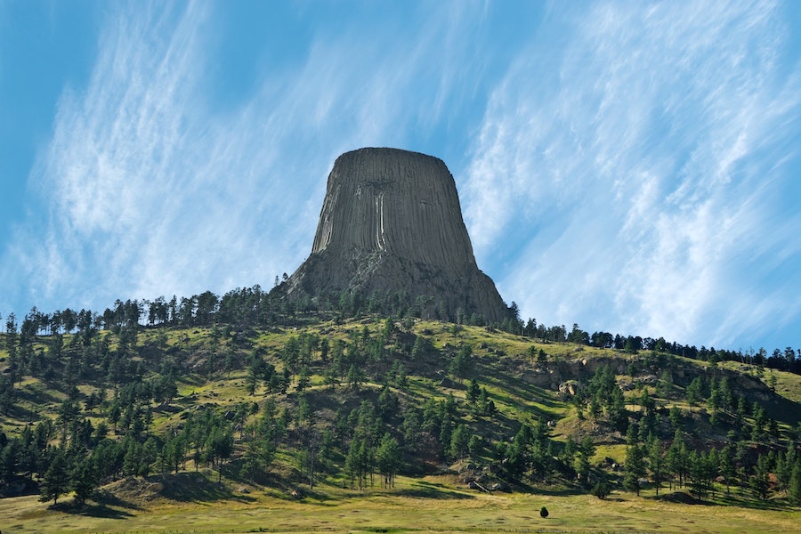
Sand Creek Public Access is one of my favorite places to camp near Devils Tower National Monument.
These dispersed campsites are just a few miles south of I-90 near Beulah. It takes just an hour to reach Devils Tower and about the same to reach Rapid City. Sturgis is just 30 minutes away.
During the week, Sand Creek is fairly quiet and peaceful. However, the camping area is quite small and fills up quickly on weekends, especially in the summer. It’s also something of a local party spot.
Small RVs and trailers (up to about 24 feet) can make it work here. The catch is there is limited turnaround space if all of the campsites are full.
Important Tip: Much of the surrounding land is private property. It’s essential to make sure you’re actually in the Wildlife Habitat Management Area before you set up camp.
Other Free Campsites Nearby: There are three other public access areas open to free camping along Sand Creek in this general area (all managed by Wyoming Game & Fish).
See on YouTube: “Sand Creek Wyoming” by David Homrok
More Info:
Sand Creek Public Access is managed by the Wyoming Game and Fish Department.
Dispersed camping is allowed for up to 14 days at a time.
Call the Sheridan Regional Office for more info: (307) 672-7418
Official Map: WGFD Sand Creek Public Access Online Map
Ayres Natural Bridge Park
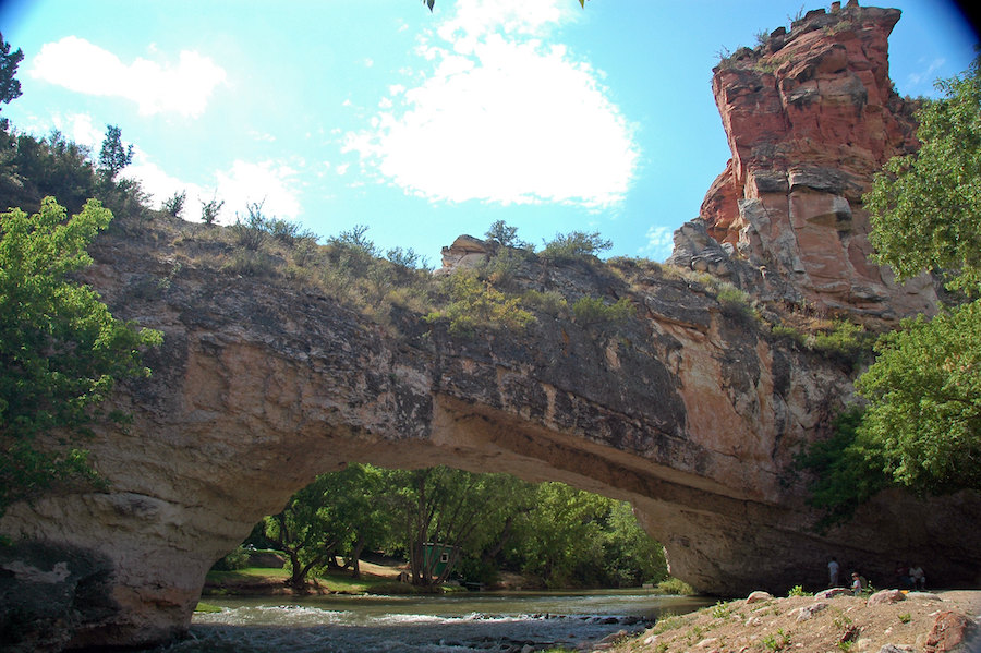
Image Attribution: “Ayres Natural Bridge (west of Douglas, Wyoming USA) 6” by James St. John, CC BY 2.0
Ayres Natural Bridge Park is a scenic and interesting place to camp off of I-25 just 20 minutes west of Douglas.
Unlike most of the campsites on my list, this isn’t dispersed camping. Instead, it’s a free developed campground managed by Converse County.
The park is incredibly clean and well-maintained, thanks in large part to the on-site camp host. There are about 10 campsites total, but overnight use is relatively light, even on summer weekends. RVs and trailers up to 30 feet are welcome.
The real highlight of camping here is the titular natural bridge, a wide red rock natural arch spanning LaPrele Creek. The creek is perfect for swimming and wading on hot summer days.
Important Info: Pets aren’t allowed here. You must also check in and register with the on-site host when you arrive, even though all of the campsites are first-come, first-served – not to mention, free.
Other Free Campsites Nearby: Bixby Public Access Area, a small fishing access area on the North Platte River, is a good alternative to Ayres Natural Bridge Park.
See on YouTube: “Ayres Natural Bridge” by Wyoming Traveler
More Info:
Ayres Natural Bridge Park is managed by Converse County.
Free camping is allowed for up to 3 nights at a time.
Call the on-site camp host for more info: (307) 358-3532
Sand Mesa Wildlife Habitat Management Area
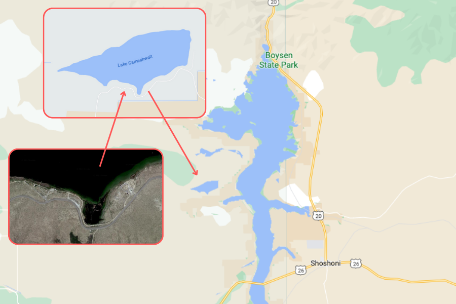
Last but certainly not least on my list of my favorite dispersed campsites in Wyoming is Sand Mesa WHMA.
Just a hop, skip, and a jump from Boysen Reservoir and Boysen State Park, my favorite campsites here are situated around Lake Cameahwait, especially along its southern side.
These consist of a mix of true dispersed campsites (little more than pullouts near the lake) and a handful of sites with picnic tables (a couple even have sun/rain/wind shelters).
It’s a pretty rough and bumpy drive in to the lake, but any passenger vehicle should make it just fine. This is an okay spot for boondocking, although I wouldn’t bring in anything longer than about 26 feet.
Other Free Campsites Nearby: Dispersed camping is allowed throughout Sand Mesa WHMA, including near Ocean Lake, Middle Depression, and Sand Mesa Number 2 Reservoir.
See on YouTube: “Beach Camping at Lake Cameahwait” by Kyle and Miranda
More Info:
Sand Mesa Wildlife Habitat Management Area is managed by the Wyoming Game and Fish Department.
Dispersed camping is allowed for up to 14 days at a time.
Call the Lander Regional Office for more info: (307) 332-2866
Official Map: WGFD Sand Mesa WHMA Online Map
How to Find Even More Free Campsites in Wyoming
The free campsites described above are my personal favorites, but they’re far from the only places for dispersed camping in Wyoming. Here’s how to find even more:
- Apps – iOverlander and FreeCampsites.net are my favorite apps to find potential dispersed campsites.
- Online Maps – Satellite view on Google Maps is great, but Gaia GPS lets you turn on USFS and BLM boundaries to make finding legal dispersed campsites even easier.
- Ranger Station – Call or stop by the nearest ranger station for current road conditions, recommended dispersed campsites, and other important info. Most also offer paper Motor Vehicle Use Maps (MVUMs) of their ranger district.
Another option (that I personally only use if I can’t find public land nearby) is blacktop boondocking in a store parking lot (like Walmart), although fewer and fewer stores are welcoming overnight campers.
Related Post: The Best Apps to Find Free Campsites
Let Me Know If You Have Any Questions
Want more info about one of the dispersed campsites mentioned above? Need recommendations in a different part of the state?
If you have any more questions at all, please don’t hesitate to leave me a comment below!
Related Post: My Favorite Free Campsites Near Yellowstone National Park